We've been to the Anza Borrego park a couple of times before, but we never had a proper 4x4 so there was a lot we couldn't explore. This time we drove there in our Toyota FJ, giving us the ability to go absolutely anywhere legal.
To make the journey there more interesting, we decided to repeat our journey of a few years back along the San Andreas fault. You can stay within a few miles of the fault all the way to New Cuyama on route 166. The route is 200 miles long from Hollister to New Cuyama, and there is no gas anywhere along it. I was glad to have an extra 5 gallons of the stuff in the can on FJ's roof.


 The first part of the route passes along the eastern edge of the Pinnacles, on route 25, a beautiful road with almost no traffic. One oddity: towards the southern end it crosses a river, and along the river bank there are a dozen or so 1950s cars buried, nose first. Why? I couldn't find anything about this on the web, so short of going and knocking on the door of the farm house, there's no way to find out.
After that you have to deviate from the fault for a while - there used to be a road that ran along it, but no more. This takes you over the Parkfield Grade, a steep and twisty road whose last few miles are dirt. It's easy when it's dry, but it was muddy this time and I was very glad
we had FJ.
Parkfield is a very strange place. It's right on the fault, and there's an earthquake research center there. There's also a cafe, where we hoped to get a hot drink, but it was closed for renovations. There's a hotel, too, very rustic with a huge fireplace, everything made from great logs, and a collection of books to read to while away the evenings going back to the 1950s.
Since we couldn't get anything to drink in Parkfield, we stopped at the restaurant by the James Dean Memorial on route 46. This was the only open place of any kind along the entire route. They do a mean fruit pie! Where the employees live, I have no idea - the nearest town is Paso Robles, over 20 miles away.
 We last drove this route about ten years ago. There used to be a closed, boarded up general store in the middle of nowhere between route 46 and route 58, but this time there was nothing left of it except a patch of bare earth. How on earth did the store ever make a living from the occasional ranch in this desolate countryside?

A few miles more brought us to the Carrizo Plain, with its giant 250 megawatt solar energy plant. Further on is dried-up lake bed. This is very visible from the air, even from an airliner at 30,000 feet. The day's weather was strange, with a dark overcast and occasional showers, and very cold too. It's an incredibly desolate place, made even more moonscape-like and spooky by the unusual late afternoon light. In the middle of the most desolate stretch of all, we came upon two cars full of kids blocking the road. Just as I wondering how to deal with this, one of them backed up, leaving a gap. What they were up to, we had no idea - maybe a drug deal? But the nearest town of any size is over 50 miles away.
As we finally reached a proper road again, it started to snow. That was really a surprise. We were very glad to get to New Cuyama. It's not much of a place, but it's the only settlement of any kind for 30 miles one way and 50 the other. And it has a gas station! - although when we arrived, only one pump was working.
There's also a hotel and restaurant, the Buckhorn. There's even an airport, or at least a runway - it closed a few years ago, but the new owners, who also refurbished the hotel, reopened the runway. I guess it makes a good $100 hamburger destination for people in LA. We spent a pleasant evening there, with a giant burger for dinner accompanied by an excellent margarita, finished by watching some local guys play pool.


 The next day's journey was mostly dedicated to the long drag across LA on a confusing variety of freeways. We'd planned to make the first part more interesting by climbing into the mountains on our way to I-5, and set off on the road up the mountain. The previous night's snow had been freezing fog a few hundred feet higher. It had left beautiful frost patterns on the grass and all the plants, and the view across the frozen hills was spectacular. But it had also left slick ice on the road. With no idea what we'd find higher up, we decided to be prudent and turn around.
 Even so the drive across route 166 to the Central Valley is spectacular, with an amazing view down from the top of the pass. The first place - barely a town - is Maricopa, and from there on the landscape is dominated by the oil industry, with giant pumps every few hundred yards.
Once we'd climbed the Grapevine on I-5, it was three boring, congested hours crossing the LA area. Further south, we stopped at Temecula. It's the nearest wine-growing area to LA, and the wineries reflect that - overpriced, pretentious DisneyWines, aimed at the weekend day-trip trade rather than serious winemaking. Further south we found the Emerald Creek Winery, a much nicer place in the hills - but although it was completely open, there was nobody there!
Along the road our attention was attracted by what looked like dozens and dozens of glider (sailplane) trailers lined up in a field. And that's just what it was, the Warner Springs Gliderport, which claims to be the busiest glider airfield in the country. It's certainly well placed, surrounded by mountains - it must have magnificent thermals, unlike Hollister where my own rather unrewarding glider flights took place.
Finally we arrived at the top of the pass into the desert, with extraordinary views from 4000 feet. In the picture below, the town of Borrego Springs is in the shade. In the far distance is the Salton Sea, and the mountains to its east. From here, it was a short but steep drive to our hotel, and then to dinner at Borrego Springs' finest dining establishment, Carlee's.
The next day's adventure is here.

To make the journey there more interesting, we decided to repeat our journey of a few years back along the San Andreas fault. You can stay within a few miles of the fault all the way to New Cuyama on route 166. The route is 200 miles long from Hollister to New Cuyama, and there is no gas anywhere along it. I was glad to have an extra 5 gallons of the stuff in the can on FJ's roof.

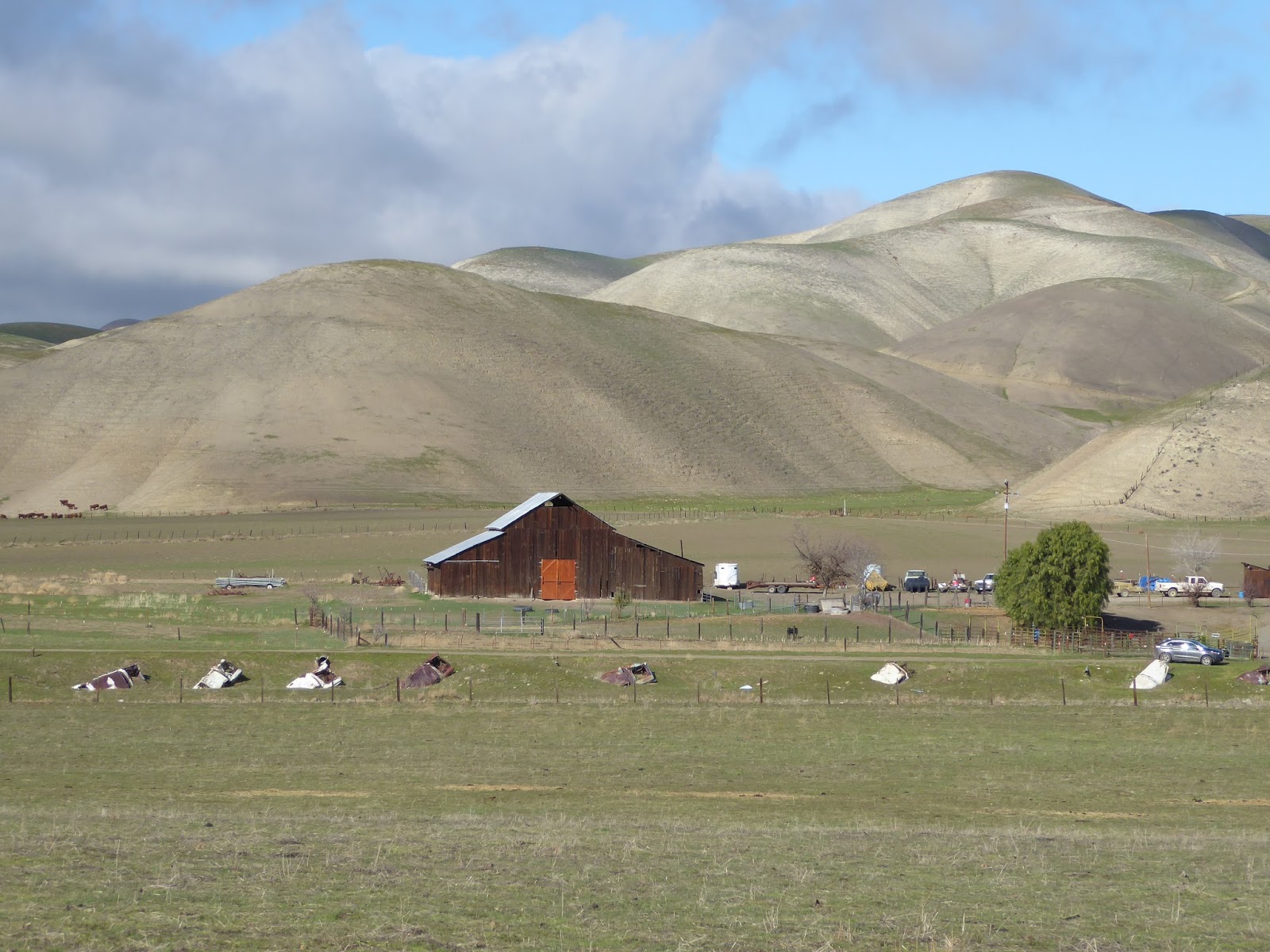
 The first part of the route passes along the eastern edge of the Pinnacles, on route 25, a beautiful road with almost no traffic. One oddity: towards the southern end it crosses a river, and along the river bank there are a dozen or so 1950s cars buried, nose first. Why? I couldn't find anything about this on the web, so short of going and knocking on the door of the farm house, there's no way to find out.
After that you have to deviate from the fault for a while - there used to be a road that ran along it, but no more. This takes you over the Parkfield Grade, a steep and twisty road whose last few miles are dirt. It's easy when it's dry, but it was muddy this time and I was very glad
we had FJ.
Parkfield is a very strange place. It's right on the fault, and there's an earthquake research center there. There's also a cafe, where we hoped to get a hot drink, but it was closed for renovations. There's a hotel, too, very rustic with a huge fireplace, everything made from great logs, and a collection of books to read to while away the evenings going back to the 1950s.
Since we couldn't get anything to drink in Parkfield, we stopped at the restaurant by the James Dean Memorial on route 46. This was the only open place of any kind along the entire route. They do a mean fruit pie! Where the employees live, I have no idea - the nearest town is Paso Robles, over 20 miles away.
 We last drove this route about ten years ago. There used to be a closed, boarded up general store in the middle of nowhere between route 46 and route 58, but this time there was nothing left of it except a patch of bare earth. How on earth did the store ever make a living from the occasional ranch in this desolate countryside?
A few miles more brought us to the Carrizo Plain, with its giant 250 megawatt solar energy plant. Further on is dried-up lake bed. This is very visible from the air, even from an airliner at 30,000 feet. The day's weather was strange, with a dark overcast and occasional showers, and very cold too. It's an incredibly desolate place, made even more moonscape-like and spooky by the unusual late afternoon light. In the middle of the most desolate stretch of all, we came upon two cars full of kids blocking the road. Just as I wondering how to deal with this, one of them backed up, leaving a gap. What they were up to, we had no idea - maybe a drug deal? But the nearest town of any size is over 50 miles away.
As we finally reached a proper road again, it started to snow. That was really a surprise. We were very glad to get to New Cuyama. It's not much of a place, but it's the only settlement of any kind for 30 miles one way and 50 the other. And it has a gas station! - although when we arrived, only one pump was working.
There's also a hotel and restaurant, the Buckhorn. There's even an airport, or at least a runway - it closed a few years ago, but the new owners, who also refurbished the hotel, reopened the runway. I guess it makes a good $100 hamburger destination for people in LA. We spent a pleasant evening there, with a giant burger for dinner accompanied by an excellent margarita, finished by watching some local guys play pool.


 Even so the drive across route 166 to the Central Valley is spectacular, with an amazing view down from the top of the pass. The first place - barely a town - is Maricopa, and from there on the landscape is dominated by the oil industry, with giant pumps every few hundred yards.
Once we'd climbed the Grapevine on I-5, it was three boring, congested hours crossing the LA area. Further south, we stopped at Temecula. It's the nearest wine-growing area to LA, and the wineries reflect that - overpriced, pretentious DisneyWines, aimed at the weekend day-trip trade rather than serious winemaking. Further south we found the Emerald Creek Winery, a much nicer place in the hills - but although it was completely open, there was nobody there!
Along the road our attention was attracted by what looked like dozens and dozens of glider (sailplane) trailers lined up in a field. And that's just what it was, the Warner Springs Gliderport, which claims to be the busiest glider airfield in the country. It's certainly well placed, surrounded by mountains - it must have magnificent thermals, unlike Hollister where my own rather unrewarding glider flights took place.
Finally we arrived at the top of the pass into the desert, with extraordinary views from 4000 feet. In the picture below, the town of Borrego Springs is in the shade. In the far distance is the Salton Sea, and the mountains to its east. From here, it was a short but steep drive to our hotel, and then to dinner at Borrego Springs' finest dining establishment, Carlee's.
The next day's adventure is here.

No comments:
Post a Comment