Day 2 here, more pictures here.
We decided to visit Titus Canyon on Sunday morning. This is another of those roads where you wonder whether a regular car could do it. And again, the answer is
no! You really do need the Jeep.
Titus Canyon is a long one-way road, which is entered in Nevada nearly at the ghost town of Rhyolite, an amazing rags-to-riches-to-rags story in itself. Gold was found in there 1905. By 1907 the population was 5000, and three separate railroads were under construction for hundreds of miles across the desert. Yet in 1910 the mines were exhausted. The railroads had barely reached the town when the mines closed in 1911. By 1920 there was nobody left.

The outward journey is along one of these wonderful long, straight-to-the-horizon roads that you find in the desert. Then, with one of Rhyolite's quarries just in front, you spot a tiny sign to a gravel road. Turning off, you bump for miles down the easy, if rough, track, headed back to the mountains that form the eastern boundary of the park. At first the entry to the mountains is easy as the track winds and climbs. Then suddenly in front is a great gash across the mountain: the climb up Red Pass at a steady 20% gradient. The road is straight, but it's a
long way down - you
really don't want to come off it. Then at the top you wonder where the road has gone. You scan the horizon, in vain, until you realise that it is right
down there. The descent is anything but straight, a succession of hairpin bends dropping dramatically into the valley. Each twist and turn opens up a new vista of applied geology, the strata of billions of years exposed immodestly to your gaze.
Eventually we arrived at the reason this road exists, the ghost town of Leadfield. Only a few buildings survive, and in truth there never really was a town. The post office opened in 1926 and closed in 1927. The whole thing, including the road, was a stock scam.
From there it's a few more miles of mostly-easy gravel road to Titus Canyon itself. In the Canyon the road drops over 2000 feet, gradually narrowing until in places it's barely wide enough for the Jeep, the walls towering hundreds of feet feet above. In the middle of all this there are a couple of places wide enough to pull off the road. We chose one of them for our lunch. The thing that struck me is the silence - all outside sounds are absorbed by the canyon walls, and there are few birds. Naturally there's very little light. It's an extraordinary and beautiful place.
The canyon ends, quite suddenly, with a magnificent view of the northern part of the valley, still nearly a thousand feet below at the foot of the alluvial fan.
We'd started later than we intended (that has never happened before!), so we didn't have time for my original plan, which was to drive the full length of the West Side Road to Warm Springs Canyon, at the southern end of Badwater. Instead we settled for the first of the trails up the western side of the valley into the Panamint range. The west side has always been tantalising - it probably
can be driven in a regular car, but I've never done it. The east side has high cliffs and a steep drop from the 5000 feet of Dante's View, but the west side has a huge alluvial fan that rises from nearly 300 feet below sea level in the valley, to over a thousand feet.
In the past several of these canyons led to passes that would eventually take you to the Panamint valley on the other side of the range. The southernmost was Wingate Wash, a long, gentle climb without any real mountaineering. Unfortunately it now leads only to the China Lake naval weapons research center - which, as you can imagine, is
not open to the public. Nowadays there isn't even a road up the wash - it has become part of the designated wilderness, which means you can only get there on foot or by horse. Given the heat, terrain and drought, that isn't a very practical option either, so you can't really get there at all.
The next trail northwards, Warm Springs Canyon, was the first path that the Bennet-Arcan party, who gave Death Valley its name, used unsuccessfully to try to escape. It's the only that still provides a through vehicle route, via Butte Valley, Mengel Pass and Goler Wash. That is firmly on the list to try another time.
This time, though, we tried Trail Canyon, which starts just a mile or so from West Side Road's crossing of the valley floor. It also used to be a crossing, thanks to a dramatic road built to provide access to a tungsten mine in the 1950s which led right up to the ridgeline at Aguereberry Point (which incidentally is one of the few Basque place names in the US). In the 1990s the road was badly damaged by a flood and the Park Service decided not to repair it.

The valley floor crossing is spectacular. This area is called the "Devil's Golf Course", consisting of hard salt-infused mud which, by some physical process, turns into foot-high ridges and spires with sharp peaks of salt crystal. It would be extremely difficult to walk over, but the road is good and gives a sweeping panorama of the whole valley.
Shortly after turning south again, a small wooden sign points to a barely-visible gravel track that leads up the alluvial fan. The first mile or two is in reasonable condition, but after that it gets rockier and the ride gets worse and worse, until even at a walking pace it was too much for Isabelle's back. Just when she was asking me to give up, she spotted a big rock and asked to be left for a while. I was hesitant, but with a gallon of water and one of our two satellite beacons, and within hiking distance of the valley floor, it didn't seem too risky.

I continued on my own, which meant I could go a bit faster. Immediately I came to the crossing of a deep gully, with no real track but just rocks to clamber over. On the far side things improved, but not for long. Another mile of bumping over rocks led to a place where the trail simply disappeared altogether. There was no sign of tyre tracks, and nothing to indicate the route except gully walls about a foot high and fifty feet or so apart. The trail could be anywhere inside them. I tried for a while, and occasionally saw just a single set of tyre tracks which I tried to follow. But time was getting on - we wanted to be across the mountains while there was still plenty of daylight. I decided to quit before I broke anything, and retraced my path to where Isabelle was sitting happily in the shade with a book - her picture shows the returning Jeep, just before the tricky gully crossing. Later, I learned that the tracks had been made by Richard - he had gone another three miles and still found no sign of the former trail. Now that it really needs nowhere, I wonder whether the Park Service will even bother to grade it again.

A short drive took us back to the valley crossing, with a spectacular view of the Artists' Palette. Then it was back to the airport.
At the weekend the military airspace is generally not in use, which I'd confirmed with Joshua Approach by phone in the morning. That meant we could choose our own route home and avoid the detour via Coaldale. We took off from Furnace Creek and turned more or less towards Bishop, but with a route that took us over our previous day's drive, with a spectacular aerial view of the Racetrack, Hidden Valley and the road up to Lost Burro Mine - hence the aerial picture of the Racetrack which appears in Day 2.

Even so the route has to be chosen carefully. Since the oxygen system in the plane was not working, we could not go higher than 12500 feet except for a short while (30 minutes). But the range that separates the park from the Owens Valley has peaks over 11,000 feet, so it's best to pick a route through one of the passes. And then a route through the high peaks of the Sierra Nevada is needed. For this I climbed to 13,300 feet (staying below the opposite-direction altitude of 13,500 feet) and took the valley which leads northwest from Mammoth Lakes and then to the upper valley of the Tuolomne River. It's spectacular, but you
really hope the engine doesn't stop. It
should be possible to make it either to the Meadows or down into Owens Valley, but I'd rather not have to find out.
We arrived at Palo Alto airport at the exact time of sunset, the sun dropping finally over the horizon as we flew our final approach. It had been a wonderful weekend, full of discoveries, natural beauty and amazing experiences. We'll definitely be doing it again.


 The valley floor crossing is spectacular. This area is called the "Devil's Golf Course", consisting of hard salt-infused mud which, by some physical process, turns into foot-high ridges and spires with sharp peaks of salt crystal. It would be extremely difficult to walk over, but the road is good and gives a sweeping panorama of the whole valley.
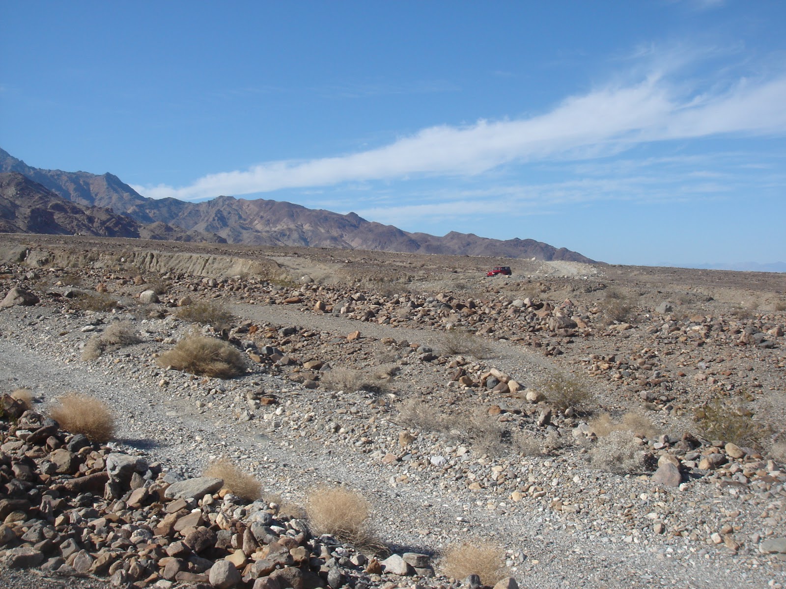


No comments:
Post a Comment