
We had been to Death Valley several times before. The first time we flew there, landing the time-share Cessna 182 I had at the time at the Furnace Creek airstrip. This is one of the very few places where you can land with the altimeter showing a negative value. There was no car rental at the time, and we stayed just one night at the Furnace Creek Inn, not leaving the grounds except to return to the airport. It was May, still not yet summer, but it was so hot that during the night I had to sit in front of the air conditioner for five minutes to get back to sleep. In the morning we went for dip in the pool just before it was time to leave. We wondered how we could dry in time, but it wasn't a problem. In the couple of minutes it took to walk back to our room, we were bone dry, even our hair.

The Inn was built in the 1920s by the Pacific Borax Company to develop tourism there as an alternative to borax mining. It works fairly well as a kind of time-warped luxury resort. The alternative is the Ranch, originally a low budget motel which has improved over the years. We stayed there for our New Year visit, making the most of the huge, warm spring fed swimming pool. It was a "blue moon", when the moon is full twice in the same month, and we have fond memories of swimming late at night under the full blue moon. We were in the very convivial atmosphere of the Ranch bar to welcome the New Year at midnight. After years of experience we have our own preferred rooms there, with an uninterrupted view of the Panamint mountains and convenient access to the outside, overlooking the golf course, where we can enjoy al fresco meals.
Off-Road Dreams
 | |
| Our Red Jeep | |
 | |
| The Racetrack | |
 | |
| In Titus Canyon |
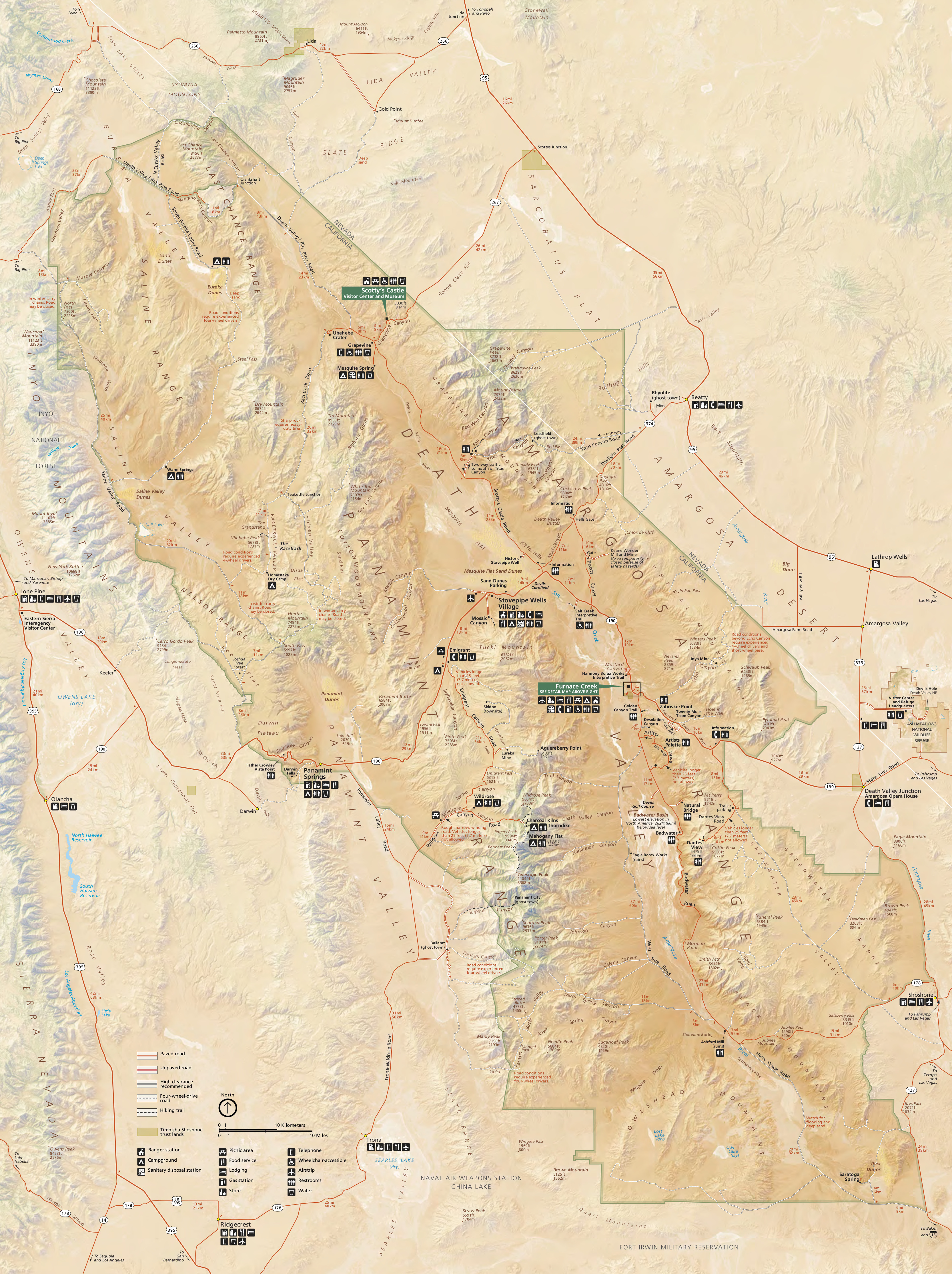
Even so it is an amazing place, which had already captured our imagination. Not only is it the lowest spot in the US, but also the hottest in the whole world. The record temperature is 134°F, established in 1913. Birds were dropping dead from the sky. There is almost no rain, and so very little vegetation or soil. The geology, layer upon layer of twisted rock formations, is on naked display. Yet when it does rain it is usually in destructive torrents that carve canyons and hurl giant boulders down from the mountains. In 2004 a flood destroyed one of the major roads and killed two people, while in 2015 the northern access to the park at Scotty's Castle was destroyed in another flood and may reopen in 2020.
I read every single trail in the Mitchell book, dreaming of what they must be like. The National Geographic map was my other companion, tracing out the routes. Finally in October of 2012 we arranged to fly once again to Furnace Creek. It's not an especially long flight, a couple of hours, but you fly over a truly extraordinary amount of emptiness once the Sierra Nevada is crossed. The big difference from our first flying visit was that by now, a Jeep rental place had opened. So we could fly in, rent our bright-red Jeep, and set off straight away on the journeys that I had been dreaming of for months.
We did what I call "Death Valley 201" - the most interesting of the not-too-hard trails. We started with the Racetrack, an extraordinary place where football sized rocks move mysteriously over the smooth mud. The next day we visited one of our (now) all-time favourites, Titus Canyon. When we returned I wrote blogs about our first off-road adventures in Death Valley.
FJ Joins the Family
I was completely overwhelmed by what we had experienced. I read and re-read the Mitchell book almost feverishly. I wanted to do more of this, and I wanted our own off-road vehicle to do it. The Jeep was an excellent off-road vehicle, but its on-road comforts were a different matter. From our home in the Bay Area to Death Valley or anywhere else like it is a long, long drive - Death Valley takes about 8 very boring hours if you just pound along the highway, longer if you take detours to make it more interesting. So we needed something that would be comfortable for those long drives, yet capable of even the most extreme trails.

Since I was planning to make extensive modifications, it didn't make sense to buy a new one. After various false starts, I found a 2010 model at a local Toyota dealer which ticked all the right boxes. My family thought I was mad, and I was having doubts myself. I figured that if it really did turn out to be a bad idea, I could always sell it again.
Our new vehicle was instantly baptised FJ, along with Hermine (my wife's Audi A4) and La Petitte (my Audi TT). Now I had to decide what modifications were necessary. The most important thing was to make it trail-proof, which means protecting everything underneath. I spent several chilly January weekends installing thick metal plates to cover everything from the radiator backwards to the fuel tank. I let the garage make the suspension modifications.
I spent a lot of time deciding which tyres to fit. There's a big choice, each with its advocates and its particular advantages. Given the amount of highway driving we would do, noise really mattered - and this is not a strong point of sturdy off-road tyres. The ones fitted when I bought it made a constant droning which made conversation difficult. Others that I'd test driven were even worse. Finally I decided on Bridgestone truck tyres. It took me a while to realise, after they'd been fitted, why suddenly there was such a lot of wind noise - previously it had been inaudible, masked by the racket from the tyres.
FJ's First Adventure
Our first trip to Death Valley with FJ was in April 2013, six months after we bought her. We went the long way round via Tahoe, since the Tioga pass was still snowed in. For the first time we spent a night in Bishop, the only significant town on US395 all the way from Reno until it crosses the mountains into the LA area. Even so there's not much to it, apart from Eric Schat's amazing bakery. We have since spent several nights there, and only ever found one functioning restaurant.
We entered the Park via the Saline Valley road. It's about 95 miles long from north to south, entirely unpaved and with high passes at either end. In winter the snow sometimes makes it inaccessible for days. It's a spectacular journey, never boring with the ever changing scenery. FJ lived up to our expectations both in comfort for the long highway journey and in agility for the off-road stretches.
A short side trip from the main valley road took us to the Saline Springs, an optionally nudist bathing spot. We didn't partake, but it's a fun place. From there the south pass road took us, eventually, to the Panamint Springs Resort, where we spent the night. It's a quirky place. Mainly it's a big camp site, but back then it had a few ancient cabins. Since then it has acquired some new ones, much more comfortable.
I'd really wanted to dive into the deep-end and drive the Mengel Pass and Goler Wash road. Isabelle wasn't keen, and with hindsight this was a good choice. We have since driven it, and while it's a beautiful journey it would have been a bit beyond my experience at the time. Instead, we visited the almost-ghost town of Ballarat, and then tried the easier side roads off the Wildrose road.
 |
| Aguereberry Point with resident crow - Dante's View is the peak at the right of the picture |
This was when we discovered Aguereberry Point, a summit over 6000 feet above the western side of Death Valley with astounding views along its whole length. It is almost opposite the much better known, and more visited, Dante's View. We've been there many times since. Usually we have been alone, occasionally there might be one other car there. It could be done with a regular car, most of the time, but I wouldn't be keen. The main risk is the tyres - losing one would be unfortunate, but losing more than one would be a big problem.
The name was obviously Basque, which intrigued us. Eventually it led to a deep interest in Jean-Pierre (Pete) Aguereberry, who built the road himself from his mine at the bottom of the hill, and to Isabelle giving a talk about him in his home town of Mauléon, France.
Chicken Lippincott
 Death Valley is addictive. The more you do, the more you find that is still to be done. Since that first trip with FJ we have been back about ten times, sometimes on our own, sometimes with friends and family. The "Death Valley 201" trails - the Racetrack, Titus Canyon, Aguereberry Point - we have done several times, with different visitors.
One of our most memorable trips was with our friends Donna - now sadly no longer with us - and Paulo, in 2015. They drove from their home in Colorado in their brand new Jeep Cherokee.
 We drove to the Racetrack. From there our planned route was down the Lippincott Mine Road, one of the most extreme trails in the Park. The road was bulldozed down the side of a mountain to provide truck access to the Lippincott lead mine. It descends (or ascends, depending which way you go) 2000 feet in about 5 miles. In places there are washouts which leave barely enough room for FJ or a Jeep, not to mention adverse camber that threatens to hurl you into the canyon's void. I can't imagine driving a truck loaded with tons of lead ore down it, relying on 1940s technology brakes - but they did.
 Despite its reputation, the road is not that difficult as long as you have the right vehicle - I've driven down it twice now. There are only a few places where you need to pay close attention to wheel placement, though a single storm could make it impassable. The Park Service runs a grader down it every now and then, unlike some of the trails.
Still, it was brave decision to take a brand new vehicle down it. FJ had no problems but we had to be careful with the Jeep's regular car-style tyres. We have a wonderful picture taken at the bottom, with a look of delayed shock on Donna's face like something from a horror cartoon. A beer at the Panamint Springs Resort was a big help.
And the chicken? Dining possibilities at Furnace Creek are limited. There's a fancy, pretentious and overpriced restaurant at the Inn, and a much more basic diner at the Ranch. One meal per trip there is OK, but that's enough. Once we understood that, we have taken care of our own food. The evening after our Lippincott experience, we dined on a simple, impromptu meal made from chicken, beans and tinned tomatoes purchased in the general store and cooked on a tiny camping stove. Since then, Chicken Lippincott has been a staple of our trips to Death Valley.
Steel Pass and the The Vertebra Scale
For a long time I wanted to drive Steel Pass. This provides another access to Saline Valley from the north. Starting from a good dirt road, it leads first to the extraordinary Eureka Dunes. These rise 700 feet above the surrounding valley, with magnificent views. You rarely see other human footprints as you climb, because they are quickly erased by the wind, though critter prints of various sizes are common. After Eureka Dunes the road goes through a long patch of soft sand - four-wheel drive and even lockers essential - and then into the narrows of Dedeckera Canyon. What makes this special is a series of dry falls that are at the limits of drivability, the last one especially. I watched several videos on Youtube of people doing them. If I hadn't, I would never have believed our FJ could do it.
In fact, though, it was not even very hard. The canyon is so narrow that there is only one possible passage, so it's just a question of making sure you are lined up correctly. I even made my own video here.
 | |
| Dedeckera Canyon Steps |
All books of off-road trails include some kind of difficulty rating. Mitchell's is typical - 1 means you can do it in a rental car, carefully. A rating of 5 means that even with FJ it is going to be a challenge. These scales all consider the driver's viewpoint. After Steel Pass, Isabelle came up with one from the passenger's point of view, which she calls the Vertebra Scale. One vertebra means easy, maybe shaken up a bit in places but nothing worse. Five vertebrae is reserved for the descent from Steel Pass.
I thoroughly enjoyed the whole road and would readily do it again, but it has been made clear to me that it would be on my own!
Mengel Pass - Finally!
 | |
| Striped Butte and the Geologist's Cabin |
I'd wanted to drive this road on our very first trip with FJ, but Isabelle insisted on waiting until we could have two cars. This is certainly prudent although these days it carries so much traffic that even if you broke down, someone would be on hand. Finally in October 2019 Isabelle went to a lot of trouble to organise a two-car outing. Paulo came again from Colorado with his Cherokee, though sadly this time alone. We had friends and family from England as well, making a total of five of us.
 | |
| Looking down into Anvil Canyon |
It's a long trip so we started early, beginning with the West Side Road that runs down the "wrong" side of the Badwater flats. It passes several interesting spots including Shorty Harris's grave and Shorty's Well - named for a different Shorty. Finally we turned right on the Warm Springs road, climbing up the alluvial fan and eventually entering the broad canyon and passing by the mine.
We stopped at the Geologist's Cabin for our picnic lunch, with Striped Butte in full view in front of us. There were several other cars there, some planning to go through the pass, others not. One of the groups had been staying in the cabin.
A couple of us drove down the trail to the head of Anvil Canyon. This is now wilderness though originally it was the only drivable road up to the valley. It was from here that the "Death Valley Germans" made their disastrous decision in 1996 to try and get back to the main valley in a totally unsuitable two-wheel-drive rental car. The discovery of their remains, in 2009, is a fascinating if macabre story.
 | |
| Goler Canyon |
Finally it was time to start the last climb to the summit of Mengel Pass. The road rapidly becomes fairly technical, requiring careful tyre placement. Even so, FJ's extensive underbody protection several times did its job as a high rock thumped against one of the quarter-inch aluminium plates that protect everything that matters.
There were several vehicles at the summit, including one that had come that far by accident, looking for something much lower down. The descent, on the other side, was similar - a few technical stretches separated by easy but slow rocky trails. Finally we arrived at the junction for the Barker Ranch. Much has been written about this, the final hiding place for the Manson gang.
The last stretch of the road leads through Goler Canyon. I was completely unprepared for the beauty of this wild, rugged place, every bit as spectacular as Titus Canyon. From there it's a long drive on a good dirt road to the almost-ghost town of Ballarat, passing the huge Briggs mine which was still active until recently. There is still a general store in Ballarat, but all it sells is beer - which was extremely welcome.
Dunes
 | |
| Eureka Dunes |
On our most recent trip, in March 2020, we decided to visit the Ibex Dunes in the far south of the park. On the way we passed through Shoshone, a tiny settlement just outside the Park which was put on the map by Charles Brown, a powerful advocate for eastern Inyo County who ended up as a California senator, yet still lived very modestly in his Shoshone home.
On a previous trip we drove close to the date farm at Tecopa, and this time we made the detour to visit it. It has an adequate water supply from the Amargosa River, not long before the latter turns through 180 degrees to head north into Badwater and eventually to disappear there. It's an interesting place, well worth a visit. It's possible to do a long hike from there through the Amaragosa canyon, though this time we didn't, to find the path of the old Tonopah & Tidewater Railroad. We left with some delicious dates, excellent date bread, and a surprising book which I'll mention later.
 | |
| Buckwheat Dunes from the pass after Ibex Spring |
There is another dune system in the Buckwheat Valley, one more mountain range west of the Ibex Spring. It's almost unknown - I only knew of it thanks to Steve Hall's excellent blog. We only had time for one dune though, so we stopped in the mountain pass and ate our picnic lunch in full view of the dunes, before returning to the main Ibex Dunes road.
 | |
| Ibex Dunes |
On the same trip we also drove to the top of Trail Canyon. On our very first excursion with the Jeep we'd tried this, but we were put off by the rough road and we were running out of time. This time we persevered. One of the highlights is a very short stretch where Aguereberry Point is visible from the road, via a side canyon. Many years ago there was a perilous zig-zag road carved into the hillside which led up there, built for a tungsten mining operation in the 1950s. A flood in the 1970s washed it away and it has not been remade.
 | |
| The Morning Glory Mine Camp in Trail Canyon |
At the top, the road splits in two, each fork terminating at the extensive remains of a mine after some seriously rough road. There used to be many mines up here, early ones for gold and silver and later ones for lead, antimony and tungsten. Looking up the canyon we could see the still snow-covered Wildrose Peak. It's possible to hike further to more mine remains, but it would be hard work. Apart from the thousands of feet of climb, walking in a stony wash is difficult even for a short distance. We discovered this hunting for the spring which supposedly exists. We found some vegetation but no water.
The Panamint Dunes are at the northern end of Panamint Valley, reached via six miles of easy but slow dirt road, with frequent washouts that have to be taken at walking pace. A long time ago it was possible to drive right up to them, but now they are part of the Wilderness Area and the closest you can drive is still a four mile hike. We contented ourselves with taking telephoto pictures, before continuing on an extremely rough trail leading up the mountainside to the remains of the Big Four Mine.
 |
| Panamint Dunes, from the nearest road |
Resources
Maps
- The free map given away by the Park when you pay for admission is not bad. It's available online too. It shows where all the trails are, though it would be no good for driving them.
- My favourite map is published by National Geographic. It's printed on water-resistant plasticised paper; my copy has survived ten years of constant use, both at home and on the trail.
- For driving the trails, or hiking, there is no substitute for the USGS 7.5 minute sheets. They show every trail, every structure and every contour line. When you are in the middle of nowhere and suddenly come to an unexpected fork in the road, they are lifesavers. For preparing a trip at home, caltopo.com is perfect. On the trail, I use the Topo Maps app on an iPad 4 Mini with 128 GBytes. That's enough to hold maps for most of California and the surrounding states - and the maps themselves are free. I've managed to load missing sheets in the most unlikely places, thanks to LTE.
Trail Guides
- By far the best trail guide book is the one that got me started on all this, Roger Mitchell's Death Valley SUV Trails. It describes nearly every drivable trail, with detailed instructions and interesting historical background especially about the mines.
- The other excellent guide is Backcountry Adventures: Southern California. This doesn't cover as many trails, but is very thorough for the ones it does cover. It has a huge amount of background information about people, places, flora and fauna, geology and much else, which all by itself justifies the price of the book.
- The Explorer's Guide to Death Valley National Park is good too, as thorough as Mitchell.
Books
- Pete Aguereberry: the extraordinary life story of the man who left his village in Basque France to fulfill his dream of becoming a gold miner, and succeeded.
- Digonnet, Hiking Death Valley: this thick book by a Stanford professor describes hundreds of hikes in Death Valley. Most of them are only for the extremely fit, but still enjoyable reading for the rest of us.
- Loafing Along Death Valley Trails: a collection of stories about Death Valley personalities, especially Charles Brown of Shoshone.
- A History of Mining in the Death Valley National Monument: notable for the incredible amount of material (nearly 600 letter-size pages), this is an official survey from the 1980s to determine what the Park Service should try to preserve. The material on some of the individual mines could fill a book by itself.
- These Canyons are Full of Ghosts: what makes this book extraordinary is that it was written by someone who was still mining for gold in the 1980s, half a century or more after most gold mining came to an end. It is packed with interesting stories. My copy comes, new but already rather the worse for wear and signed by the author, from the Date Farm in Tecopa.
- Adventures with a Desert Bush Pilot: about a couple who flew their tiny plane (a 95hp Ercoupe) all over the desert, including many adventures in Death Valley. A must read for any pilot.
On the Web
Searching the web for Death Valley related topics could take up months of your time. There is an incredible amount out there. Luckily there are plenty of people who not only have extraordinary adventures, but take the time to write about them and write well.
My own special mention goes to Steve Hall's Death Valley Adventures: details of over 200 hikes, most of them extremely challenging, that Steve has undertaken in the park with his friends, his wife, and even carrying his young child.